Munich
Orientation Convention in Jinan
Jinan has the option to be world's first city that has realized an international orientation standard, an idea from a Munichian inventor to simplify and harmonize worldwide all orientation means: signage, cartography, navigation devices and verbal expressions.
Within this city, it is (will be) possible to find any target with easy brain work, that means
| - without maps, | - without names, |
| - without illogical numbers | - without arrows |
| - without floor marks | - without square grids |
| - without colors | - without compass or other navigation devices |
Buildings, crossings, stop points, bridges, postal codes, house numbers etc. have logical addresses like
Jinan Zoo Park StatusQuo©
JIN m11 r52
Shandong stadium m7 r20
Yaoqiang airport m1:35 r285
which are easy to understand if you associate the city with a clock as follows:
 |
The Quancheng (Spring City) square was (will be) defined as a pole m0. Around this pole, the horizon is divided in 12 "horizon hours" m1 to m12 , whereas m12 points to north. Horizon hours are divided in horizon minutes. These are not angles but DISTANCES to the horizon hour, in steps of approx one "block of houses" or 100 meters. Example : m3:10 ( read "emm three point ten" or "emm three ten" ). This is a line situated in a distance of 10 x 100m from the horizon hour m3, which points to sunrise. The convention for horizon minutes is very easy: the greater, the later. |
Considering the distance to m0 as r = radius also in steps of blocks of houses, logical position codes StatusQuo© (where you are) for targets, buildings, crossings etc. come into existence, e. g. as shown on the picture:
crossing StatusQuo© JIN m7:14 r30
The prefix JIN says that the position code is valid for Jinan.
In simple words:
"r" is a numbering starting FROM m0,
"m" is a north-direction-based numbering AROUND m0
and this simple methode covers a gigantic market gap:
l o g i c a l and easy understandable p o s i t i o n codes.
Natural Cartography©: a map with such a polar grid has innovative characteritics, see www.volksnav.com/map Please be aware about the fact that some of the above mentioned targets aren't on map but the codes make it possible to imagine where they are situated !!
Signage: StatusQuo© addresses will be integrated within the existing signage, see www.volksnav.com/lollipop, or be indicated on so-called Orientators©, the signage of the future. Vertical Pointing©: additional to the position information, a round symbol called center or pole pointer will be placed on their periphery to allow to detect the direction m0 according to the following conventions:
etc. Acc. to the same convention, a square symbol points to north = m12. The picture reveils: m12 is behind, the pole is right hand
|

Orientator© |
Navigation / VolksNav©:
The local navigation with the help of such codes is called VolksNav©. As proceeded today with house numbers, VolksNav© is nothing else than the major/minor comparison between "r" and "m" values:
Simply proceed according to 1 -2 -3 :
| 1
-
Positioning
|
Turn your body until m0 will be BEHIND. In this position,
etc. Beginners have to turn physically, after some exercises anyone will be able to do this by his imagination power. In case you look at above shown Orientator©, you'd have to turn to left, correct? |
|||||||||
| 2
-
r-comparison
|
Ask yourself: must I move inwards or outwards? ( = is the target radius greater or smaller than the actual one?) |
|||||||||
| 3
-
m-comparison
|
Ask yourself: must I move to “later” (clockwise) or to earlier? ( = is the target m later or earlier than the actual one?)
|
Let's see an example:
Your target is: Zoo park m11 r52
If you've lost orientation on named crossing m7:14 r30,
so you must go
- outwards (radius r52 is more than actual r30 )
and
- to "later" (clockwise) ( m11 is "later" than the actual m7 )
This may seem to be unfamiliar, but the orientation based on cardinal points is used for some thousand years and imaginary clocks are used by soldiers, boy scouts, pilots, blind people etc. for more than 100 years. On a real situation, VolksNav© can be learned within few minutes, that means, faster than the most seeking times.
Vision:
 |
Mobile applications:
Very soon also navigation devices and mobile phones will indicate such logical position codes and cardinal points , see www.volksnav.com/london You're invited to download the demo program for pocketPC with/without GPS from www.volksnav.com. |
Natural World Co-ordinates: the same addressing methode will soon also be used
- indoor www.volksnav.com/deutschesmuseum
and
- within the whole globe, see www.watchrose.com. This method allows to address in a worldwide harmony
cities and small towns
road entrances / exits / crossings
bridges
tunnels
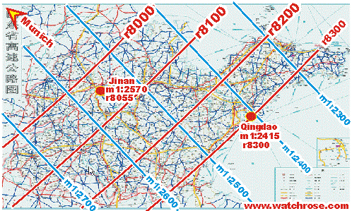
etc . Acc. to this, the international City Code of Jinan is
WatchRose© m1:25 70 r80 55
Just comparing the codes for example of Jinan and
Qingdao WatchRose© m1:24 15 r83 00
it is possible to evaluate that
- the position of Jinan is "later" and closer to Munich than Qingdao, more exactly
:2570 - :2415 = 155 km later
r8300 - r8055 = 245 km closer
- the distance between both locations, the hipotenuse, will be between 245 and 245+155 km.
- for advanced users:
the egocentrical direction Qingdao / Jinan (to later/to inside) is QuoVides(R) 9, see www.quovides.com
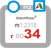
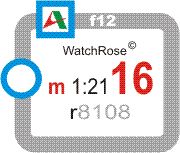
On city entrances, road exits, road crossings, expressway sections etc., the signage could look like this:
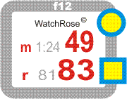
Orientator© with north and center pointer. The frontal direction is called f12, the back direction f6 and so on. |
Signification: - Distance to Munich (radius): 8183 km. - The world pole Munich is right hand (f2), so the driving direction is clockwise. Note: for the local navigation VolksNav©, only the red figures and the center pointer are needed - Distance to the horizon-hour m1 (Munich-Sapporo) : 2449 km. In this direction, this value will increase (m1:2450 etc.) - The north direction is right hand (f4). This information isn't relevant for VolksNav© but for the classical orientation.
|
|
|
Driving ahead within this expressway section, you can only reduce your radius |
|
|
Driving ahead within this expressway section, you can only reduce the m-value |