VolksNav in Dublin
Click or doubleClick a point on map to know the logical indoor or urban area code of that point
The convention for urban area codes is:
| StatusQuo(c) Dublin | prefix of a position code | The urban pole is the City Hall |
| m12 | basic horizon hour | from urban pole to north, m3 to east etc. |
| number after the " : " | horizon minutes | distance to the horizon hour, in steps of 100 meters The blue lines on grid show :50 minutes |
| r... | radius |
distance to the urban pole, in steps of 100m. |
This map converts lat/lon to StatusQuo by click on a simplified mode, tolerable for radius < 10 km. For a professional conversion, see VolksNav.com/mapplet
Station codes (tentative)
| name | time | radius |
|---|---|---|
| Estuary | m12:32 | r145 |
| Seatown | m12:32 | r130 |
| Swords Central | m12:26 | r121 |
| Forsterstown | m12:20 | r114 |
| ----------------------------------- transition inside/outside | r100 | |
| Dublin airport | m12:10 | r94 |
| Dardistown | m12 | r74 |
| Northwood | m11:28 | r68 |
| Ballymun | m11_20: | r57 |
| Collins ave. | m12:2 | r48 |
| Griffith Park | m12:3 | r35 |
| Glasnevin | m11:10 | r24 |
| Mater | m11:8 | r17 |
| O'Connell str. | m12:4 | r11 |
| Tara | m2:2 | r10 |
| -------------------------------------- transition north/south | m3 / m9 | |
| St. Stephen's Green | m4_2 | r10 |
| Charlemont | m5:1 | r16 |
| Line codes / line pictograms: | m12 to m5 | m5 to m12 |
 Say "line five twelve" or "12 5"
The division of the horizon into 12 directions can also be used global or indoor, example City University: addressing of buildings, crossings, exits etc.
 Centering on labyrinth, 1 unity = 10 meters
The innovative room numbering follows the same method.
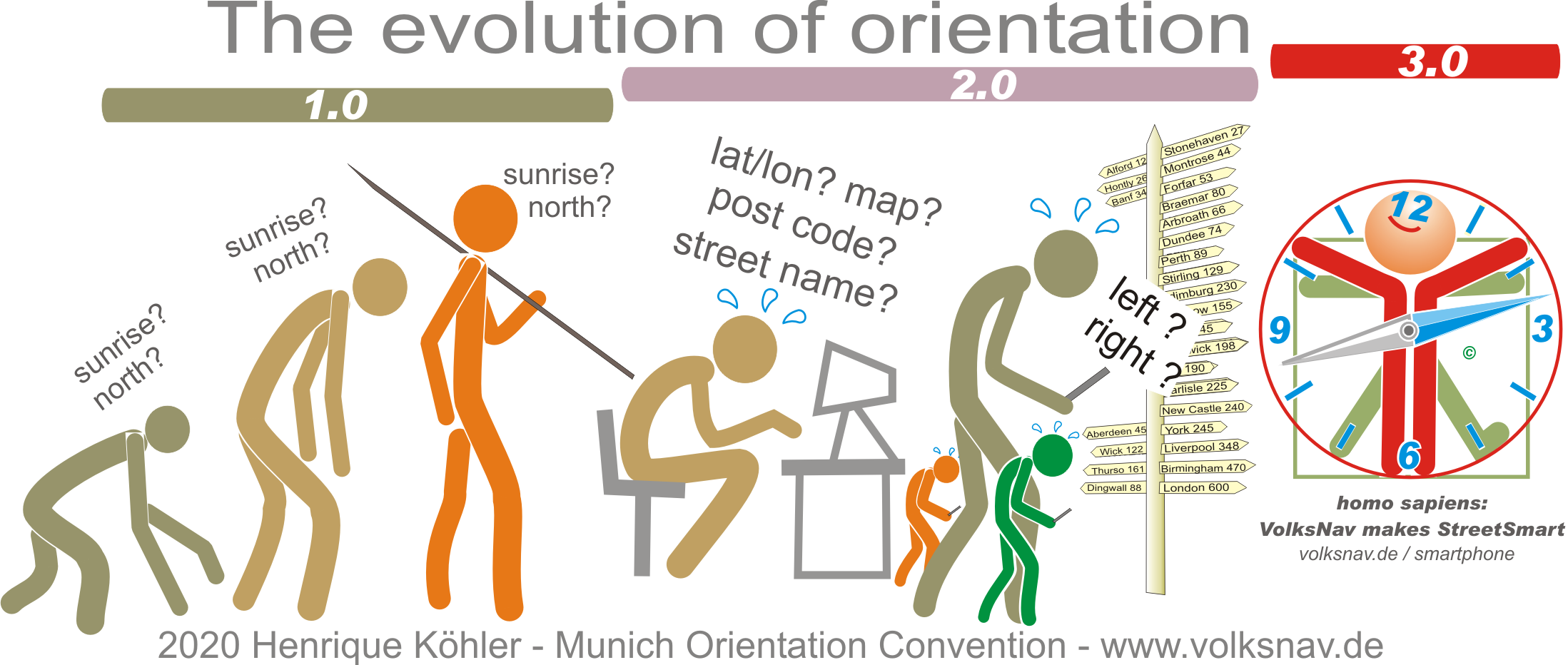
Evolution